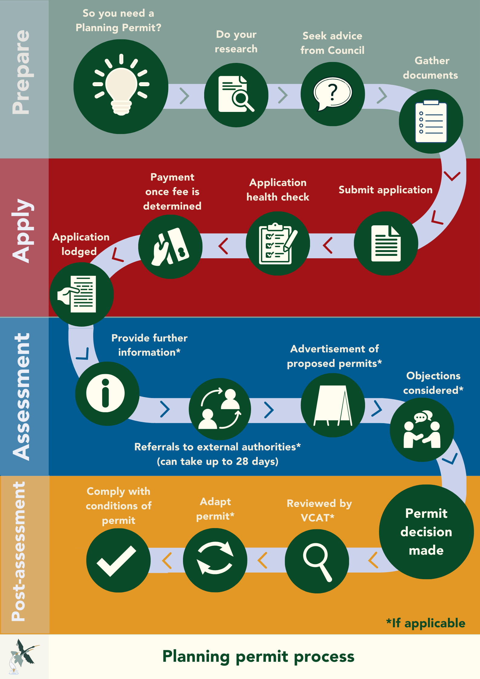
Preparing for a planning permit
Understanding planning and building
Planning permits and building permits are different and they are assessed by different teams. This means that you might need one or both depending on your proposal.
The purpose of a planning permit
Planning considers the way land is used and developed, and how this impacts the character and amenity (liveability) of the municipality.
Council’s planning scheme(PDF, 34MB) is what guides decision making and outlines objectives, policies and controls for the use, development and protection of land. Council assesses proposals for the land through planning Permit regulatory process that is aligned with the planning scheme.
A planning permit is a legal document that gives you permission to use or develop land in a certain way. It usually includes conditions and approved plans which must be complied with.
The purpose of building permit
Building is concerned with safe construction practices, and considers whether the construction work and new uses conform to building regulations, the Building Code of Australia and relevant Australian standards.
A building permit is a legal document, issued before construction commences, to ensure the building meets the minimum requirements for the health, safety and amenity of occupants and the public.
Building permits are issued by building surveyors.
If you require both a planning and building permit, you must get the planning permit before applying for the building permit. Having an approved planning permit does not mean that you can start construction without first getting a building permit.
Why are planning decisions important for our region?
The West Wimmera Community Vision outlines a future region that is somewhere that’s great place to live, work and play. Somewhere with vibrant, welcoming towns, with a thriving economy that makes the most of our strengths in farming and tourism to generate employment and ensure future prosperity.
Planning decisions are critical to creating this future. It is these decisions that will ensure we are:
- Looking after the long term needs of the people who live, work and visit and to ensure the amenity and liveability of our towns is maintained.
- Developing sustainable communities with access to jobs, services, infrastructure and community facilities.
- Protecting our outstanding local environment and ensure there is no loss to biodiversity.
- Safeguarding the economic future of our region and preserving our productive farmland.
- Ensuring that State, regional, and local policies affecting land use and development are carried out.
- Making sure that developments are sustainable and safe for residents and visitors to the region.
Understanding the planning scheme
The planning scheme is a legal document prepared by Council and approved by the minister for planning. It contains policies and provisions that control land use and development by guiding decisions of Council and other authorities. For example:
- It separates incompatible land uses so that we don’t have inappropriate adjacencies
- It triggers consultation with other important authorities outside of Council and guides their decisions on issues relating to overlays
The planning scheme applies to all private and public land and is binding on everyone, with some exemptions.
The administration and enforcement of a planning scheme is the duty of Council as a responsible authority or where specified in the scheme it may be other authorities.
If you are unfamiliar with using planning schemes, we suggest you visit the Guide to Using Victoria's Planning system
Council’s Planning scheme, amendments and related documents can be viewed here
Understanding planning controls on the land
Planning controls are the zones, overlays or other provisions included in the planning scheme that affect how a lot can be used and developed.
About zones
Every property has only one zone. Common zones include:
- residential zones (such as the township zone)
- industrial zones
- commercial zones
- rural zones (such as the farming zone, rural living zone and rural conservation zone)
- public land zones (such as the public use zone, public park and recreation zone, public conservation and resource zone, and transport zone)
Zoning aims to avoid conflicts between different types of land uses and ensures that development is appropriate for an area.
About overlays
Overlays operate in addition to zones. An overlay seeks to achieve certain design and building standards for lot, including:
- bushfire
- environmental
- land management
- heritage
- flood issues
Not all lots are subject to an overlay. If an overlay applies to a lot, it might specify additional requirements in relation to subdivisions, buildings and works, vegetation removal and other matters.
Search for property information
You can search for the planning information of a property, parcel or crown land to understand what zones and overlays apply at VicPlan
Common reasons for planning permits
Vegetation removal
- If the property is more than 4000 sqm and the vegetation is native.
- To remove non-native species of vegetation if the property is within a Heritage Overlay or Environmental Significance Overlay.
- There are planning permit conditions or other restrictions or agreements applying to the property
- The property is outside of a bushfire management overlay and you do not have exemptions to create or maintain defendable space in areas affected by a bushfire management overlay. Vegetation management for bushfire protection.
- Note: Native vegetation is not just trees and includes native grasses, areas of bush or scrub, wetlands and brushes or sedges.
Dwellings
- If the property is under 300sqm in an urban area, and you wish to develop the land with a dwelling or extend an existing dwelling
- It is proposed to construct a dwelling in a farming zone on a parcel of land less than 80ha
- It is proposed to construct more than one dwelling on a lot
- The property is in a rural area and the land is under the minimum lot size in the zone
- Overlays on the land related to heritage, bushfire, flooding, or other environmental reasons
- The dwelling does not meet the setbacks in the zone
- It is proposed to construct a shed that is not associated with agriculture or a dwelling in a rural area
Sheds and agricultural buildings
- The property is under 300sqm in an urban area
- There is no existing dwelling on the property
- Overlays on the land related to heritage, bushfire, flooding, or other environmental reasons
- A shed in a farming zone that is not associated with agriculture
- A shed that does not meet the setbacks identified in the zone
Business in township or farming zones
- Use or development of land
- Use of an existing building for business
- Displaying advertising signs
- Street trading and other statutory planning requirements
- A business that requires a liquor licence
- Hours of trading allowed under a liquor licence are to be extended
- Patron numbers under a liquor licence are to be increased
- The licensed area (‘red line’) is being extended
More information on starting a business in West Wimmera Shire
Subdivisions
- Dividing land or a building into two or more separate lots
Seeking planning advice and support
Seeking advice from Council, or a planning consultant might save significant time and help you understand what is required so you avoid costly mistakes. Council can support in the following ways.
Our website will guide you at each step in the planning permit process
This information is critical for you to understand what is required and how you can get support from Council and other authorities in the process.
- Free general verbal advice
Council offers general advice for planning enquires. Complete the form below and send it to our planning support team to discuss your proposal and provide general advice.
Planning Advice Request Form(PDF, 193KB)
Seeking written planning advice allows Council to consider the proposal and provide greater clarity more thoroughly. Planning advice can be legally binding. It important that this is provided in writing and based on a clear written description of what is proposed by the potential applicant. Planning advice can only be provided by a delegated planning officer.
To seek written planning advice, you will need to access a current Certificate of Title or planning certificate at www.landata.vic.gov.au
Planning permits are separate to those issued under local laws, building or environmental health.